One of my favourite things about my job is that I get to look at satellite pictures and it counts as work! While looking for the cloudiest place on Earth (Part 1 and Part 2), I spent quite a lot of time looking at maps of cloud around the world.
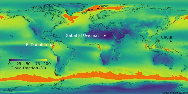
A map of cloudiness around the world, with some of the cloudiest (and least cloud) places marked with arrows.
There are lots of interesting bits of the map, but one of the clearest is the rivers. You have to change the contrast, but all around the world, rivers are less cloudy than the surrounding area.
Here is the Amazon river system (blue is less cloudy on average).
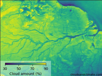
The average daytime MODIS cloudiness over the Amazon basin.
This is the Congo river
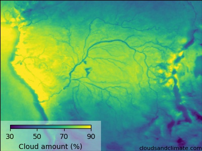
The average daytime MODIS cloudiness over the Congo region
Away from the Tropics, the St. Lawrence waterway and Hudson river stand out in the Northern US and Canada, whilst the array of rivers in the South-Eastern US are also clearly visible.
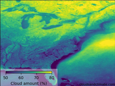
The average daytime MODIS cloudiness over eastern USA and Canada. While the St. Lawrence waterway is less cloudy than the surroudings, the Great Lakes (in the top left) are so large that they have cloudy patches in the middle.
This effect is even large enough to be visible on individual days
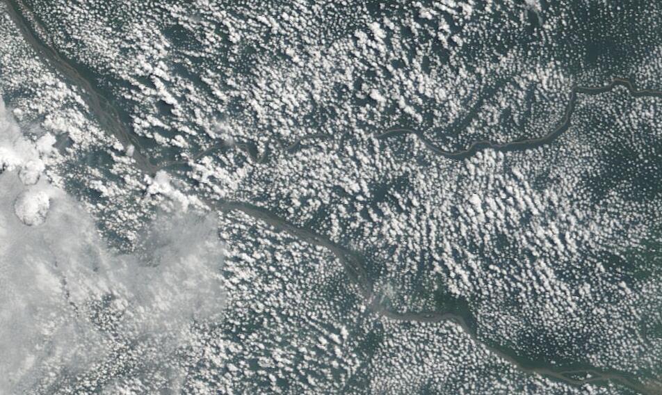
A MODIS image of the river Congo downstream of Kisangani (bottom right). Note how the clouds line up along the river edges. NASA Worldview
Those cloud free regions are the Congo river itself (top left to bottom right), the Aruwimi river (horizontal, mid-way up on the right) and even a small tributary to the Aruwimi (just above the Aruwimi).
We know that clouds need water - rivers are wet, shouldn't there be more clouds over rivers? What is going on?
Cloud free rivers
Luckily, there are a few clues.
First - the clouds are warm. The temperature of the clouds measured in the infra-red is only around 10-15C. These clouds are within about a kilometre from the surface. This means that they are strongly controlled by the properties of the surface below them.
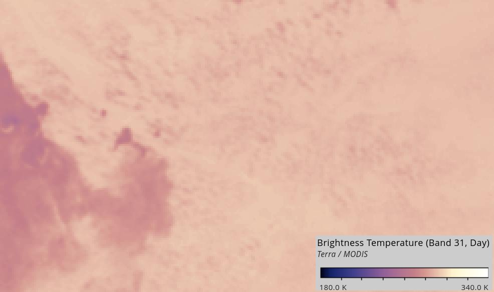
An infra-red image of the same region as the previous image. Light pinks are warmer (around 20C) and dark pinks colder (about 0C).
Second - the land-river difference in cloud forms during the morning - it is not visible at night. Have a look at this video over the Amazon river [1]. There are some clouds in the very early morning, but they are placed almost randomly. As the sun comes up, new clouds appear - but not over the river!
Convective clouds (such as thunderstorms) appear like this during the day, which suggests that we need to think about these kinds of clouds and how they form.
Heating up to cool down
To form a cloud, you to get water to condense into droplets. To do this, you need to cool the air, which increases the relative humidity. However, you often need to cool the air by 10 degrees or more to form a cloud. Cooling air by this much can take a long time (several hours). It is much easier to cool the air by heating it first!
When air near the surface is heated, it expands and becomes less dense and eventually starts to rise. It cools as it rises [2], but the atmosphere cools as you go up too. As long as the parcel of rising air stays warmer than the surrounding air, it eventually gets cold enough to condense water and form a cloud.
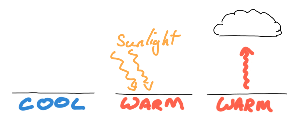
The formation of convective clouds. Sunlight heats the surface, warming the air above. When it gets warm enough, it starts to rise and can condense water to form a cloud
One way to heat the air near the surface is to heat the surface itself. This is the final step in the puzzle.
At night, both the river and the land cool down. When the sun starts to rise in the morning, it begins to heat the surface, but different bits of the surface warm up at different speeds (think about how quickly a road heats up on a sunny day, compared to a lake).
The land heats up quickly and clouds start to form over the land in the early morning. It is much harder to heat the river (as water has a relatively high heat capacity), so the river doesn't create the pockets of rising air needed to form clouds. The difficulty of heating up water means that rivers are (on average) less cloudy than the nearby land.
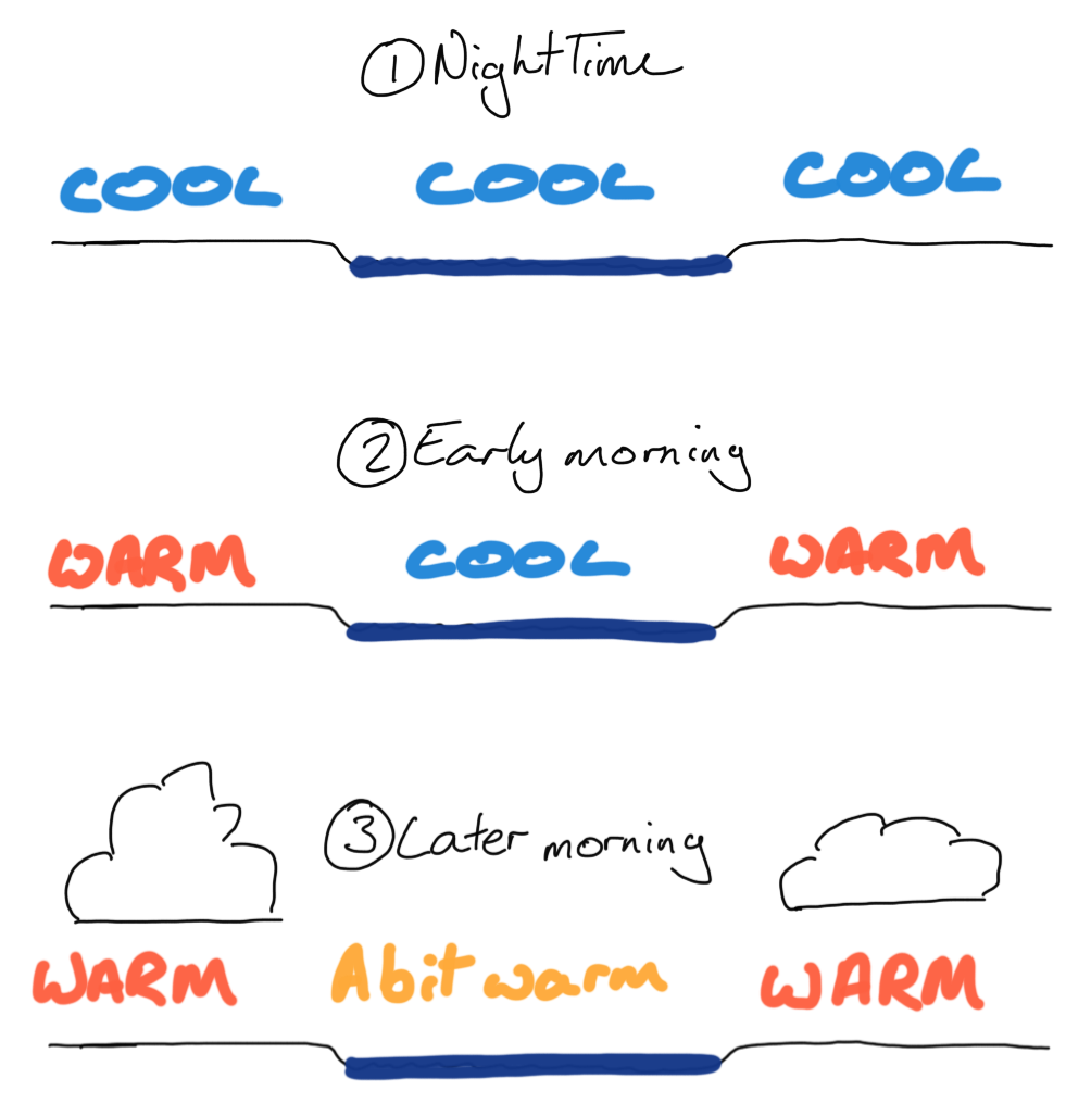
How clouds form around a river. As the sun rises, the nearby land heats up faster, forming small cumulus clouds. The river stays comparatively cold.
If the river was made from something much easier to heat up (with a lower heat capacity), such as Mercury, the clouds might form over the river instead [3]. It is the high heat capacity of water that prevents clouds from forming over rivers.
So why don't clouds form over rivers? Because they are too wet!
Comments by email
Notes
| [1] | Created using the excellent NASA Worldview |
| [2] | The atmosphere cools by around 10 degrees per km close to the surface, you you don't have to move the air very far to get it to cool down a lot. |
| [3] | Please do not try this at home |