The Arctic region is rapidly changing. The temperatures are increasing faster than anywhere else on the planet, contributing to plummeting sea ice coverage (some of the most alarming estimates suggest we could have ice-free summers in the Arctic by 2035). This newly ice-free ocean allows for more industrial activity and shipping routes in the region, which may increase local pollution levels.
Clouds are also key to the Arctic environment. For example, during polar day (when the Arctic gets near-constant daylight), the ability of clouds to cool the ocean surface by reflecting sunlight has been linked to changes in the amount of sea ice [2]. If the clouds are thicker or cover more of the ocean, the cooling effect is stronger, keeping the sea a little cooler and allowing more ice to form in the following winter.
Conversely, during the polar night, the cooling effect is non-existent – you can’t reflect sunlight that isn’t there! At night, the blanket effect of clouds becomes important [1]. More clouds in Arctic winter stop heat escaping, warming the region and enhancing ice melt.
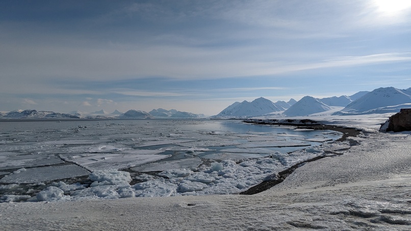
Some clouds over sea ice near Ny-Ålesund, Svalbard, April 2023. We are mostly concerned with lower clouds, but these don't look as nice in photos.
The behaviour of clouds as the climate warms is one of the largest uncertainties in changes to the climate in the near future. This problem is particularly acute in the Arctic; for example, due to the harsh conditions, it is difficult to get out there and make measurements of clouds in the region (although people do try, such as the recent extraordinary MOSAiC measurement programme). Despite the difficulty of making measurements, we still need to - they are vital to understand how Arctic clouds behave and their role in the climate system.
Cold air outbreaks
A particularly interesting class of Arctic clouds are those formed in weather events known as marine cold-air outbreaks. In the Northern Hemisphere, these occur when cold Arctic air moves southward over the open ocean, often in the wake of low-pressure systems (known as polar lows). If the air has spent much time circulating over the sea ice, it is typically very cold, dry, and clean. Even though the Arctic Ocean is naturally very cold, this extended time above the sea ice makes the air even colder (often well below freezing temperatures). This creates a situation similar to heating a pan on a stove: a heat source (the ocean) beneath a cooler fluid (the air), leading to convection. This convection effectively carries moisture and tiny particles (known as aerosols) up away from the surface of the ocean, a process crucial for creating clouds.
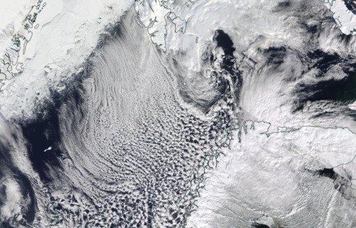
Clouds in a cold air outbreak moving from the sea ice edge near Greenland to northern Norway in March 2020– a distance of nearly 1000 km (NASA worldview).
As intense winds move the air away from the ice edge, we can see that the clouds are initially in near-parallel linear formations, which are sometimes called "cloud streets". These are typically high coverage clouds, giving them a reasonable cooling effect (although this is complicated by the fact that in the very far north, the Arctic does not get sunlight for a chunk of the year).
Downwind of this initial formation, these streets appear to break up into smaller, patchier clouds. Because these clouds cover less of the ocean surface, their cooling effect is reduced. Overall, this characteristic evolution as the clouds move over the ocean surface leads to very distinctive (and beautiful) satellite imagery.
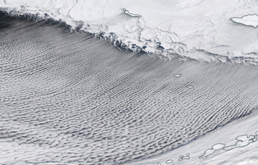
Close up of cloud streets over the Bering Sea. The coastline in this picture is about 950 km long (NASA Worldview, January 20th, 2006).
Not just pretty pictures
Cold-air outbreaks have been frequent news items in recent years. Between the deadly New York blizzards in December 2022, the record-breaking winter storms in 2021 in Texas or even the pithily named Beast from the East (or An Torathar ón Oirthear in Irish) which wreaked havoc across the UK and Ireland in early 2018, these events cause billions of dollars of damage and endanger the lives of populations in their paths. The extremely fierce winds, heavy snowfall, and sub-freezing temperatures associated with these events caused transport systems to grind to a halt, damaged infrastructure, and disrupted food supply chains. Even aside from their effects on the Arctic climate, being able to accurately predict the form and frequency of these events is a pressing target for weather modellers.
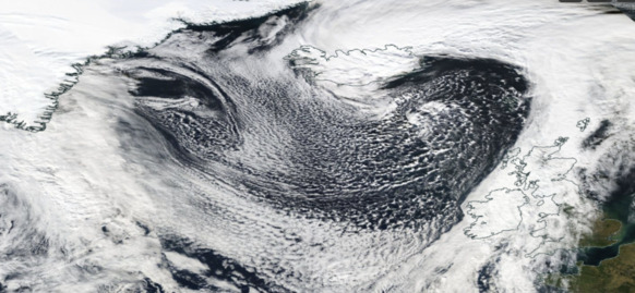
A huge cold-air outbreak stretching from the coast of Greenland and across the North Atlantic to the UK and Ireland on October 9th, 2022 (NASA Worldview).
Unravelling the Evolution of Cold-Air Outbreak Clouds
Understanding the evolution of these clouds presents its own set of challenges.
Even from these static satellite images, it is evident that the clouds in cold-air outbreaks evolve over time. Knowing what affects that development is key to understanding their climate impacts in the Arctic. Ideally, we would be able to measure the clouds at various stages in their development. While there have been some valiant efforts to fly aircraft through these events to do just that, these types of measurements are expensive, technically challenging, and only allow for a small collection of events to be sampled.
Satellites provide a great alternative. These instruments can collect data over a much greater area than can often be achieved by field measurement programmes and have been doing so for a long time (in some cases, more than two decades). There is an added benefit to using them in the Arctic – because many satellites are polar-orbiting, they pass over the region many times a day, which offers a much higher temporal resolution than is typically obtained at lower latitudes. By using years of data provided by the MODIS instrument, we investigated hundreds of these events, generating a picture of how the clouds in these events evolved hour-by-hour as they move away from the ice edge.
So how do these clouds evolve?
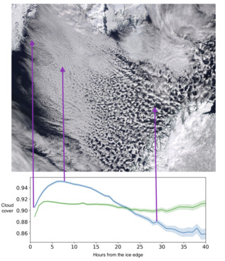
The clouds change as they move away from the sea ice - we can watch these changes with satellites.
If we just look at one cloud property, cloud cover, we can already begin to see how different these clouds are from the development of just general clouds in the region. In the plot above, the blue line shows how clouds in these cold-air outbreaks evolve; we can see the clouds appearing near the sea ice (on the left), then eventually disappearing as they more further away (to the right). Even though this is the amalgamation of hundreds of these events, this development matches what we would expect to see in satellite imagery quite nicely. The green line above shows the trajectory of clouds moving towards, not away, from the ice edge; as we can see, they don't undergo any kind of dramatic development.
Now we know what the clouds look like, we need to know what might affect their development. If we consider aerosols – the tiny particles which are necessary to form cloud droplets – we may expect that clouds which form in outbreaks that occur in more polluted environments may evolve differently to those in clean environments. If we split the outbreaks into so-called high- and low-aerosol events, we do indeed see differences in cloud development.
The plot below shows that the high aerosol clouds (blue in the figure) eventually have a small but persistently higher cloud coverage than the clouds in cleaner conditions. This is consistent with what we’d expect based on theories of cloud physics. One of the remarkable things about this plot is that the difference persists for at least 40 hours after the air has left the sea ice. Clouds seem to have some kind of memory of the conditions they've travelled through before!
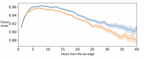
There are more clouds in polluted environments (blue) that live for longer than those in clean cases (orange) as you move away from the sea ice.
Cloud fraction is one of the most important properties to consider when trying to estimate the warming or cooling effect of a cloud. In polar day, a higher cloud fraction gives rise to a stronger cooling effect (as more of the dark ocean surface is covered by the bright, reflective cloud). This would suggest that polluted clouds in the Arctic have a stronger cooling effect, as long as you are comparing them to the super-clean cases where the air has spent a long time over the ice.
The future of cold-air outbreak clouds
As a quickly changing region, we might expect changes to the development of cold-air outbreak clouds in the future. New aerosol sources for industry and shipping would likely peak during the polar day, leading to increases in aerosol concentration. Although the impact that this will have on surface temperatures (and therefore things like sea ice extent) is uncertain, this added pollution may actually contribute to a slightly stronger cooling effect [3].
The decrease in Arctic sea ice may also in turn influence the frequency of cold-air outbreak events. Polar lows (the low-pressure systems which sometimes cause outbreaks) can only form over the open ocean, so declining sea ice cover means that there are potentially more opportunities for these to form. The receding sea ice edge may also mean that cold-air outbreaks start at higher latitudes.
Models struggle to capture these events well. To really understand what is happening in the Arctic, we need not only more measurements of the clouds, but of things like aerosol sources near the sea ice edge [4]. Our work shows us that these factors could be key to determining the influence of these clouds on the Arctic surface energy budget.
This article is based the article 'Investigating the development of clouds within marine cloud-air outbreaks', which is available to read for free. Thanks to Tom Goren (Bar-Ilan University), who worked with us on this research.
Comments by email
Notes
| [1] | You have probably noticed this - it is much warmer on cloud nights than cloud-free nights (particularly in winter), as the clouds trap the heat and stop it escaping to space. |
| [2] | This effect doesn’t work over the sea ice, as that is already white, bright and reflective, so putting clouds on top of it doesn’t make the surface more reflective, and therefore clouds don’t have an enhanced cooling effect. |
| [3] | This pollution is still bad, overall, and really should be avoided at all if possible. |
| [4] | The sea ice edge is what’s often called a "biologically active zone", sometimes supporting algal blooms so large that they can be seen from space. |