How big is a cloud?
Clouds come in a range of sizes, from a small cumulus cloud through to a massive thunderstorm. We know the cloudiest place in the wold is in Colombia, but where is the biggest cloud?
Even the smallest clouds are already quite large. Take this little cumulus cloud as an example:
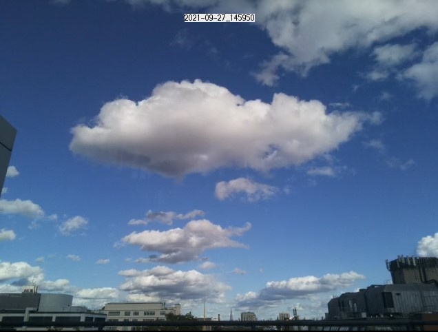
Although this cumulus cloud is small by cloud standards, it is already quite large (Imaged during CREATE).
The bottom of this cloud is about 1km from the ground [1]. Knowing this, we can convert the sizes of things in this image to sizes in the real world. This gives us a cloud width (about 1.5km) and the height (around 300m) - the same as the Shard (you can see the real Shard - bottom centre of the image, about 6km away).
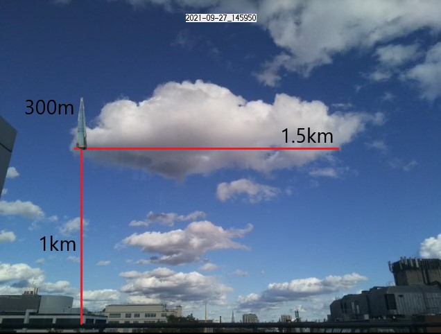
You could fit the shard almost completely inside this cloud (if you could lift it 1km above the ground)
Drawing this cloud on a map, we get a better idea of the scale. This cloud is about 2km from the camera (almost directly over Buckingham Palace), but covers a large amount central London.
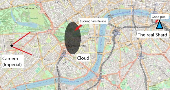
The cloud on a map of central London along with some other important landmarks. This cloud is narrower than it is wide, but it is still stretches almost an extra kilometre away from the camera.
This relatively small cloud is actually pretty large, but it wasn't even close to the largest cloud that day. Some clouds are much, much bigger, where is the biggest?
(Determining the biggest cloud is not straightforward, but if you really cannot wait, you can skip ahead to the answer).
What do we mean by big?
Actually, an even more fundamental question is - 'What do we mean by a cloud?'.
There are many regions around the world the have large cloudy regions. Stratocumulus clouds in particular form layers that stretch for thousands of kilometres, but are only a few hundred metres thick. While they cover a large area, I don't think many people would consider this a single cloud - I definitely wouldn't.
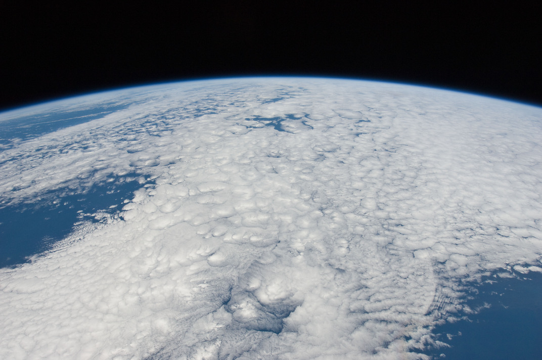
These cloudy areas are large, but are not really a single cloud, so they aren't the biggest clouds (ISS30-E-20366) Image courtesy of the Earth Science and Remote Sensing Unit, NASA Johnson Space Center.
Instead, we will consider the biggest cloud as being the one with the largest vertical extent (height). This leads to another problem - most satellites can only see the tops of clouds.
It turns out you can measure the temperature of a cloud top relatively easily and this matches quite closely to the height of the cloud top (colder clouds are higher). There are some very cold clouds out there [2], which have some very high cloud tops, but without knowing where the bottom of the cloud is, can we say they are the biggest? [3].
The bottom of a cloud
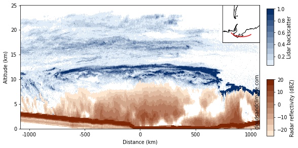
If we want to see both the top and the bottom of a cloud, the easiest way to do this is with radar. In the same way that radars can see aircraft, they can also see rain. If you have the right kind of radar, they can also see clouds and rain. Luckily, there is one of these 'cloud radars' in space (sensibly named CloudSat), so we can map cloud sizes around the world.
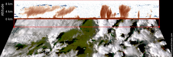
Radar cross-sections of clouds over Ireland (top) and a true-colour image (bottom) [4]. The radar points straight down, so cuts a cross section through the clouds along the red line. The brown regions in the top image show where you get stronger radar signals (thick cloud or heavy rain). The blue regions are clouds missed by the radar, but seen by lidar (a laser).
In this case over Ireland, there are two types of clouds, both with a similar height top. In the top-down image, they both look the same, but the radar shows us they are actually very different. On the left, there are thinner, high-level cirrus. They have a top at about 6km, but are only a few km thick and don't get close to the surface.
On the right, there are convective clouds. Not only do they have high cloud tops, but they stretch almost all the way to the surface. These clouds are actually raining (dark brown in the radar image), which hides the actual location of the bottom of the cloud [5]. For these cases, we can estimate the height of the bottom of the cloud using the Espy estimate for cloud base height, based on the surface temperature and humidity.
Stealthy cloud particles
Although the temperature of the cloud top gives us a good idea about its height, this depends on knowing how the temperature of the atmosphere is changing with height - this is not always simple. Unfortunately, the radar is not so great at seeing cloud tops either. The stealthy little ice crystals at the top of clouds have a very weak radar return, so are often missed by radars.
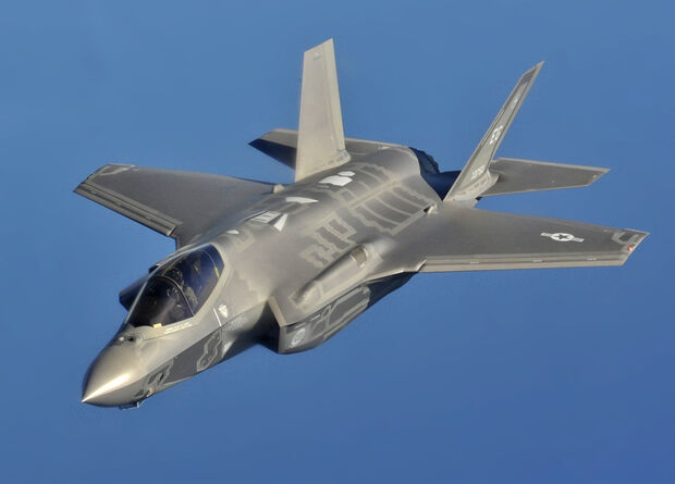
Worried about the radar stealth characteristics of your new fighter jet? Just make it a 50th of a millimetre across. Lockheed Martin, if you want any other design tips, my email is at the bottom of the article.
The solution is to use a lidar (like a radar, but using a laser). Luckily, there is also a lidar in space designed exactly for this problem! The CALIPSO satellite carries a green laser for measuring clouds and aerosols in the atmosphere. You can actually see this laser from the ground if you know where to look (don't use anything more powerful than binoculars though)!
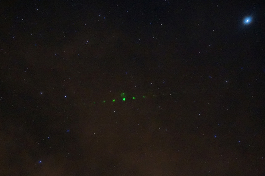
The CALIPSO satellite is orbiting at about 700km, travelling at close to 8km a second. The laser sends out a pulse of light once every 20th of a second. Capturing a photo of this from the ground is absolutely amazing! (Gregg Hendry/Ball Aerospace/NASA)
The CALIPSO lidar is extraordinarily sensitive to cloud droplets and ice crystals, allowing it to accurately measure the height of the cloud top. This sensitivity comes at a cost though - it cannot see the bottoms of thick clouds, so we still need the radar. Fortunately, these two satellites fly very close to each other. For many years, they were only 15 seconds apart! [6]
With good measurements of the cloud top and bottom, we can now locate the biggest cloud [7].
Mapping big clouds
So where are the big clouds? This map is the 3000 biggest clouds in the satellite combined radar-lidar record between 2006 and 2016 [8]. The biggest 100 are in red.
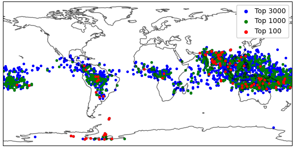
The 3000 biggest clouds in the satellite radar-lidar record. The biggest 1000 are in green and the biggest 100 are in red.
They are some clear patterns. Most of the big clouds are near the equator. While there are some big clouds over the Amazon and central Africa, the majority are over South Asia and the West Pacific. This might have been what you expected if you know about tropical weather patterns. These regions have large amounts of rising air and some really big thunderstorms, creating lots of rain [9].
All of these 3000 clouds are over 17km thick, but the biggest of these convective storms is almost 20km thick!
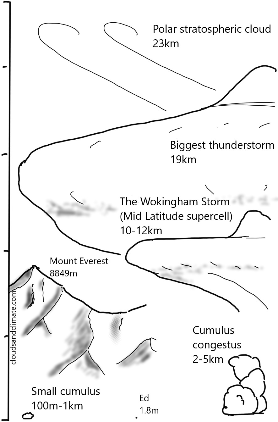
I find it hard to picture how big these clouds are. The Wokingham Storm, a large storm by UK standards and the original 'supercell' storm, was only a bit over 10-12km high. This is already higher than the height of many airliners, but the biggest thunderstorms are almost twice as tall as this!
A lid for clouds?
Thunderstorms in the tropics were always likely to be among the biggest clouds. The biggest cloud needs a low cloud base, this means a low surface altitude in a humid location. The tropical ocean fits this perfectly.
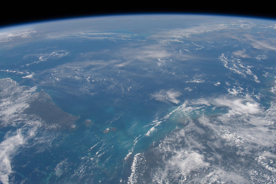
The tropical ocean near Australia, a perfect place for big clouds (NASA/JSC).
You also need to have a high cloud top. The maximum cloud top height is limited by how temperature changes in the atmosphere, setting a 'lid' on clouds.
Clouds form in rising air and hot air rises as it is less dense than its surroundings. In the lower part of the atmosphere (where we live), temperature decreases with height [10]. This means a bit of air rising from the surface can remain warmer (and hence less dense) than the surrounding air, continuing its trip upwards. However, at the tropopause (usually between 10 and 15km), temperatures start to increase again. The rising air is now denser (and heavier than its surroundings), so it stops rising, limiting the height of the cloud.
You can see the tropopause in this picture of large thunderstorms over the Caribbean. They are so intense, that they increase in height until they reach the tropopause, which caps how tall they can grow [11].
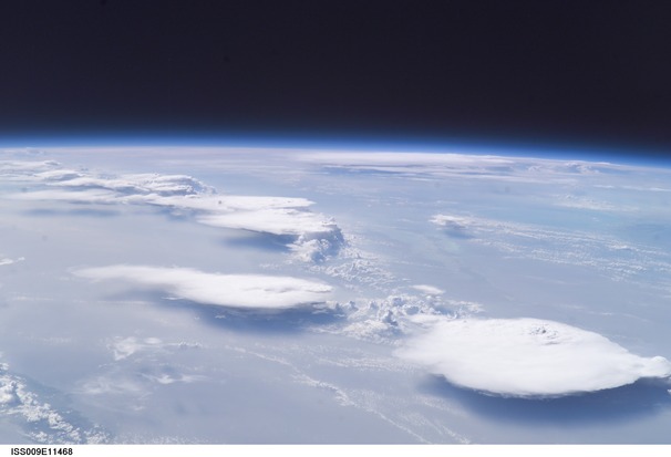
Flat-topped anvils on thunderstorms, where their height is limited by the tropopause. Big clouds need a high tropopause (NASA/Johnson Space Center)
The height of the tropopause varies around the globe, but is the highest in the tropics, near the Equator. As it limits the height of thunderstorms, this then explains why we see the biggest thunderstorms over the tropical ocean, particularly Indonesia.
The biggest clouds?
The competition for biggest thunderstorm in the records comes down to these two clouds. This one, over northern Argentina
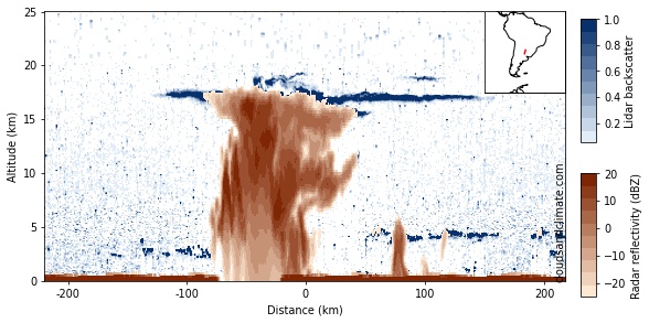
Biggest thunderstorm number 1 (BT1) - over Argentina in 2010. 19.6km thick. The orange regions are the radar signal and the blue regions are the lidar signal (in regions with a small radar signal).
and this one, over the Gulf of Carpentaria near Australia
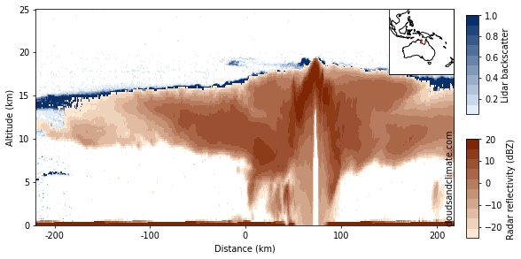
Biggest thunderstorm number 2 (BT2) - near Australia in 2007. 19.2km thick. The biggest thunderstorm in the record.
According to the criteria we set out above, thunderstorm number 1 is the largest. It is not entirely a fair comparison though. BT1 is near the South Atlantic Anomaly, which sounds like something out of the X-Files, but is actually a regions where the Earth's magnetic field weakens, causing noise in the lidar signal (the blue speckle for BT1, compared to BT2).
I am much more confident about the height of BT2, which has a strong radar return right to the top [12], making it the biggest thunderstorm in the combined radar-lidar satellite record!
However, although these tropical thunderstorms are large, they are not the biggest clouds on Earth. If you look back at the map of the biggest clouds, there are a large amount over the Antarctic! While the tropopause (and so the cloud lid) is lower here, what if you could form clouds above the tropopause?
Breaking through the cloud ceiling
Deep in the Antarctic winter, hidden up high in the darkness and cold, a special kind of cloud forms. Most clouds on Earth are formed almost entirely of water. While water plays a role in these clouds, it is nitric acid that drives their formation, with water collecting onto the nitric acid particles. Only forming below -78C, the polar stratospheric clouds (PSCs) form high up in the atmosphere, at altitudes up to about 25km.
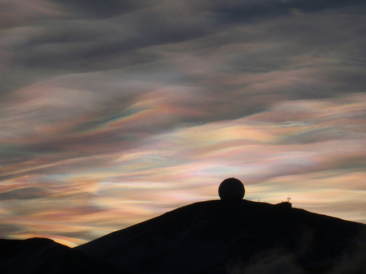
Polar stratospheric clouds over McMurdo station, Antarctica (Wikipedia).
Forming so high allows these cloud to have an extraordinary vertical size. While they are not very dense (unlike the thunderstorms), some of them form near 25km and stretch right down to the troposphere. With the tropopause not limiting their height, these are the biggest clouds in the world.
Radar (orange) and lidar (blue) cross sections of the biggest cloud in the world (maybe).
This is the overall biggest cloud on record, which formed downwind of the West Antarctic Ice Cap and the Ellsworth Mountains. By forcing air to rise, the mountains generate an upwards travelling wave in the atmosphere that forms these absolutely colossal clouds [13].
The biggest clouds in the world
If you live in the mid-latitudes (like me), you probably see mid-sized storms relatively often. You might even be lucky enough to see a really large thunderstorm. To see these super-large polar stratospheric clouds though, you will need to take a bit of a trip. It is dark and cold in Antarctica over winter, but the rewards are worth it (if you want to see the biggest clouds in the world that is). Please send me any nice pictures you get!
Cloud sizes, with the author for scale
Comments by email. The limited spatial sampling of CloudSat and CALIPSO means that there are almost certainly other very large clouds out there (although with a height that is not as well validated). If you have any other contenders, please let me know!
Notes
| [1] | From the ceilometer at Heathrow airport. |
| [2] | This paper has the observation of the coldest cloud observed by the VIIRS instrument, at an amazing -111.2C! |
| [3] | We also restrict ourselves to clouds formed of condensed water. While some volcanic plumes can reach the mesosphere, these are not clouds in the way cirrus or cumulus clouds are, so we exclude them here too. |
| [4] | Kind of - in reality you are seeing photons coming from a range of different distances into the cloud, but most of them come from close to the nearest cloud edge. |
| [5] | The radar return from a cloud depends very strongly on the size of the cloud droplets/ice crystals, with large particles giving a much, much stronger radar return. This is why rain shows up so brightly, but there is little signal from the top of the clouds, where the ice crystals are too small for the radar to see. |
| [6] | CloudSat and CALIPSO were not the only satellites in this formation. At one point, the A-Train constellation (A for afternoon, as it passes overhead at approximately 1.30pm local time) had six satellites in it |
| [7] | There are a few other technical details. We use the DARDAR-MASK product, which combines CloudSat radar and CALIPSO lidar data onto a uniform grid. As we can have multiple layers of clouds overlying each other, we count the cloud thickness from the cloud base to top in a single vertical column, ignoring any gaps of less than 100m. If the gap is larger than that, we split this into two, thinner, cloud layers. To prevent counting the same cloud multiple times, we keep only the biggest cloud within 100km horizontal distance. |
| [8] | This comes out to just under 2 billion cloud profiles! |
| [9] | This is the ascending branch of the Hadley circulation, one of the main characteristics wind patterns in Earth's atmosphere. The other half is the descending air at about 30 degrees north and south (where we get large deserts, and the least cloudy place on Earth). |
| [10] | You have probably noticed this if you have walked up a mountain, or looked at the temperature screen when on a plane,. |
| [11] | Some air parcels can make it through the tropopause, but not by much. They fairly quickly sink back down again to levels below the tropopause. These are the so-called 'overshooting tops', forming above the most intense convective locations. |
| [12] | If you look below the highest point of BT2, you can see that the radar signal apparently decreases in the middle of the storm! This is not a real reduction in cloudiness though, but a result of the higher parts of the storm having such a strong radar reflection signal, that very little radar energy makes it far enough into the middle of the storm. We only get a weak return from these parts of the storm, even though the amount of cloud and rain drops would give a strong signal to a more powerful radar. Some radars are able to see into the middle of these intense storms, but they are less sensitive to clouds than the CloudSat radar. |
| [13] | It is not a clear win though. In a thunderstorm, air can pass all the way from the bottom to the top of the cloud, making it pretty clearly a single cloud. While some ice crystals form high up in these polar stratospheric clouds, it is very unlikely they will fall all the way to the bottom of the cloud. While the mountains can create a cloudy region stretching high into the stratosphere, should this count as a single cloud if it is really many smaller clouds merged together? |